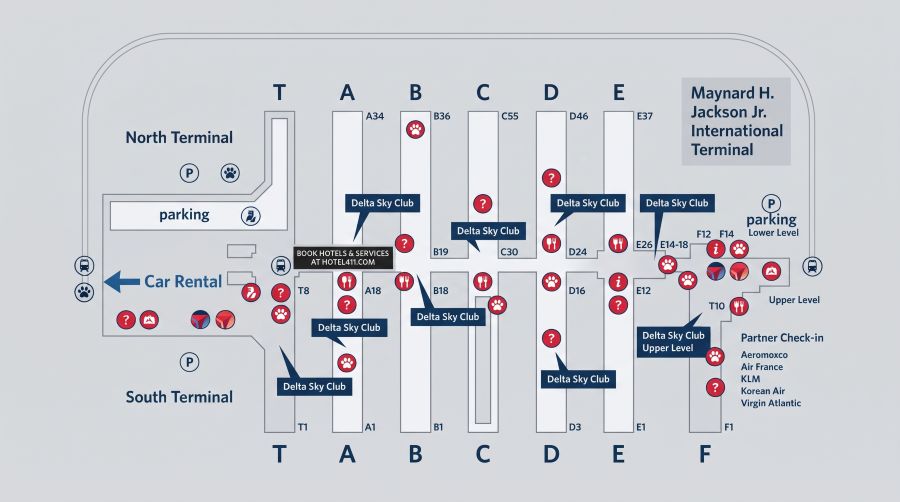
- Atlanta Airport Terminal Map: Concourse Layouts, Gate Diagrams, and Airfield Wayfinding Guide
- Concourse Directory: Gate Counts and Architectural Alignments
- Airfield Transit Spine: Plane Train and Pedestrian Tunnels
- Subterranean Plane Train Network
- The Transportation Mall Walking Corridors
- Digital Tools and Navigation Resources
- Airfield Geography: Satellite Views and Terminal Footprints
- Five Parallel Runways
- Terminal Landside Split
- Wayfinding Advice for Rapid Terminal Navigation
- Operational Metadata Verification
Atlanta Airport Terminal Map: Concourse Layouts, Gate Diagrams, and Airfield Wayfinding Guide
Understanding the architectural blueprint of the world’s highest-capacity aviation complex begins with reviewing a comprehensive atlanta airport terminal map. Hartsfield-Jackson Atlanta International Airport (ATL) covers over 4,700 acres, utilizing a parallel spine design featuring two landside terminal hubs and seven airside concourse islands. Because domestic and international facilities sit on opposite sides of active runways, having clear spatial orientation is essential to moving between check-in lobbies, subterranean transit shuttles, and boarding gates.
Whether you need a dynamic, web-based interactive map hartsfield jackson authorities provide or prefer to review static gate blueprints before your flight, this operational resource details the full concourse layout atlanta airport maintains. From tracing train routes across the airfield to identifying quiet rest spaces, this visual guide helps travelers transfer smoothly across every passenger building.
Advertisement
End Advertisement
Concourse Directory: Gate Counts and Architectural Alignments
Seven parallel concourses are situated between the Domestic Terminal complex on the west and the Maynard H. Jackson Jr. International Terminal on the east.
| Concourse | Active Gate Range | Primary Carrier Operations | Key Terminal Amenities |
|---|---|---|---|
| Concourse T | Gates T1 through T21 | American, United, Delta Domestic | Attached directly to Domestic Main Checkpoint |
| Concourse A | Gates A1 through A34 | Delta Air Lines (Domestic Hub) | Delta Sky Club (Center & Gate A17), Food Court |
| Concourse B | Gates B1 through B36 | Delta Air Lines (High-Density Domestic) | Flagship Delta Sky Club, Minute Suites, Tech Shops |
| Concourse C | Gates C1 through C57 | Delta Connection, Southwest Airlines | Central Marketplace dining, local retail boutiques |
| Concourse D | Gates D1 through D46 | Spirit, Frontier, Delta Domestic Overflow | Narrow layout, gate hold charging banks |
| Concourse E | Gates E1 through E37 | Delta International & Domestic Widebody | Delta Sky Club with showers, One Flew South |
| Concourse F | Gates F1 through F14 | Foreign Flag Carriers & Delta Overseas | Int’l Arrivals FIS Hall, The Club at ATL, Sensory Room |
Referencing the complete gate map concourses a b c d e f t comprise highlights that Concourse T is the only boarding area connected directly to the domestic ticketing lobby on foot. The other six concourses sit as parallel airside islands linked exclusively via the subterranean Plane Train and moving pedestrian tunnels.
Advertisement
End Advertisement
Airfield Transit Spine: Plane Train and Pedestrian Tunnels
The central movement corridor at ATL runs directly beneath the midpoint of every terminal structure.
Subterranean Plane Train Network
The automated Plane Train travels along a 3-mile loop connecting the Domestic Baggage Claim station to Concourse F. Operating continuously with trains departing every two minutes, it is the primary transit mode when navigating atlanta airport map routes. Riding between adjacent stations takes approximately 90 seconds, enabling cross-airport transit from Domestic Baggage Claim to Concourse F in under 12 minutes.
The Transportation Mall Walking Corridors
Positioned directly above the train tracks, an illuminated pedestrian tunnel equipped with moving walkways runs uninterrupted from Concourse T through Concourse F. Walking between concourses takes 5 to 8 minutes per segment. The underground path also houses museum-quality cultural exhibits, including the “A Walk Through Atlanta History” corridor between Concourses B and C, and the “Flight Paths” forest art installation between Concourses A and B.
Advertisement
End Advertisement
Digital Tools and Navigation Resources
Modern terminal wayfinding incorporates mobile-first interactive platforms alongside traditional downloadable schematics.
- Interactive Concourse Wayfinding: Utilizing the mobile digital wayfinding map atl airport integrates provides turn-by-turn walking directions, estimates walking times between gates, and pinpoints active dining venues near your departure lounge.
- Physical Kiosk Directories: Touchscreen informational kiosks positioned at every concourse center core offer instant visual routing to restrooms, mother’s nursing pods, pet relief areas, and airline help desks.
- Offline Reference Documents: Keeping an offline or printable airport map atl travelers can view without cellular connectivity ensures seamless navigation through subterranean corridors where wireless signals can occasionally drop.
Advertisement
End Advertisement
Airfield Geography: Satellite Views and Terminal Footprints
Viewing an overhead or satellite map atlanta airport reveals the symmetrical engineering that allows ATL to handle over one hundred million passengers annually.
Five Parallel Runways
The airfield features five east-to-west parallel runways (8L/26R, 8R/26L, 9L/27R, 9R/27L, and 10/28). This alignment allows simultaneous triple instrument landings and dual takeoffs during peak operational banks, minimizing flight holding patterns above the Atlanta metropolitan airspace.
Terminal Landside Split
Reviewing the structural hartsfield jackson terminal and gate diagram clarifies that domestic ticketing occurs at the western edge off Interstate 85, while the international terminal sits at the eastern edge off Interstate 75. No landside roadway links the two terminal lobbies directly inside the secure area; passengers driving to the wrong curbside must take airport perimeter shuttle buses or drive twelve minutes around the outer airfield perimeter.
Advertisement
End Advertisement
Wayfinding Advice for Rapid Terminal Navigation
Use this essential visual guide to atlanta airport terminals to stay oriented and minimize walking fatigue during flight connections:
- Always Head to Concourse Centers: Escalators descending to the subterranean Plane Train and moving walkways are located at the exact center midpoint of every concourse (between Gates 18 and 19 on most concourses).
- Follow Letter-Numbered Gate Overhead Signage: Gates are sequenced numerically outward from concourse center cores, with low numbers extending northward and high numbers extending southward.
- Check Overhead Monitors Before Walking Corridors: Flight Information Display Systems (FIDS) mounted above center-core escalators display live departure assignments. Confirm your boarding gate before walking the length of 30-gate corridors.
Operational Metadata Verification
- Post Category: /maps/
- Post URL: /maps/atl-airport-terminal-map/
- H1 Title: ATL Airport Terminal Map
- H2 Descriptive Title: Atlanta Airport Terminal Map: Concourse Layouts, Gate Diagrams, and Airfield Wayfinding Guide
- Meta Title: ATL Airport Terminal Map: Concourse Layout & Gate Diagram
- Meta Description: Navigate Atlanta Airport with our complete terminal map. Explore Concourses A through F, Plane Train stops, printable gate layouts, and wayfinding at ATL.
- Post Page Excerpt: <h2>Key Terminal Amenities</h2> <p>Navigating the world’s busiest airport is seamless with a verified Atlanta Airport terminal map. Discover the complete concourse layout spanning Concourses T, A, B, C, D, E, and F, connected by the rapid subterranean Plane Train and underground pedestrian art walkways.</p> <h3>Key Terminal Amenities</h3> <p>Explore gate-by-gate concourse diagrams, learn how to transfer between Domestic and International terminals, access digital interactive wayfinding tools, and download printable airport maps to streamline your connection through ATL.</p> <ul> <li>Underground Plane Train transit stops and walking tunnels</li> <li>Concourse layout maps for Concourses T through F</li> <li>Domestic Atrium to International Terminal connections</li> </ul>
- Navigation Description: In-depth visual and operational guide to the Atlanta Airport terminal map, covering concourse layouts, gate diagrams, Plane Train routes, and digital wayfinding tools.
- Top 10 Search Terms Integrated: atlanta airport terminal map, interactive map hartsfield jackson, full concourse layout atlanta airport, printable airport map atl, digital wayfinding map atl airport, gate map concourses a b c d e f t, navigating atlanta airport map, hartsfield jackson terminal and gate diagram, satellite map atlanta airport, visual guide to atlanta airport terminals